Service
Scan to BIM
Location
Calgary, AB
Industry
Industrial & Manufacturing
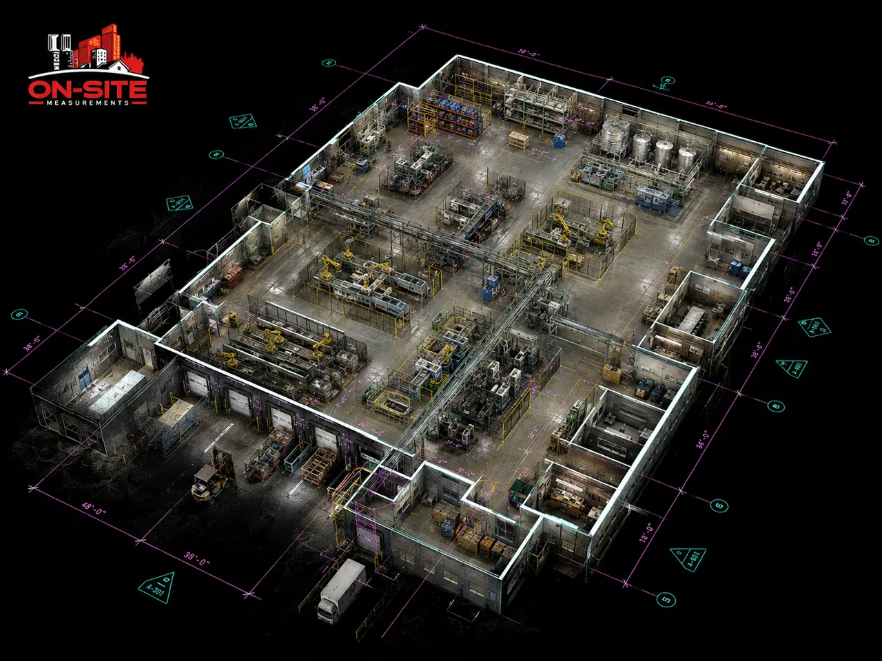
Calgary's industrial sector includes a broad range of facility types: processing plants, manufacturing facilities, distribution warehouses, equipment yards, and support buildings across the city's industrial areas in the northeast, southeast, and the broader Calgary Region. Many of these facilities were built decades ago and have undergone multiple modifications without comprehensive drawing updates. When retrofit projects, process upgrades, or facility expansions are planned, design and engineering teams often find that the available documentation does not reflect current conditions.
Scan-to-BIM addresses this by producing a Revit model from a laser scan of the actual facility. For the service itself, see Scan to BIM in Calgary. This page describes how Scan-to-BIM is used on Calgary industrial projects, what the workflow involves, and what project teams typically receive.
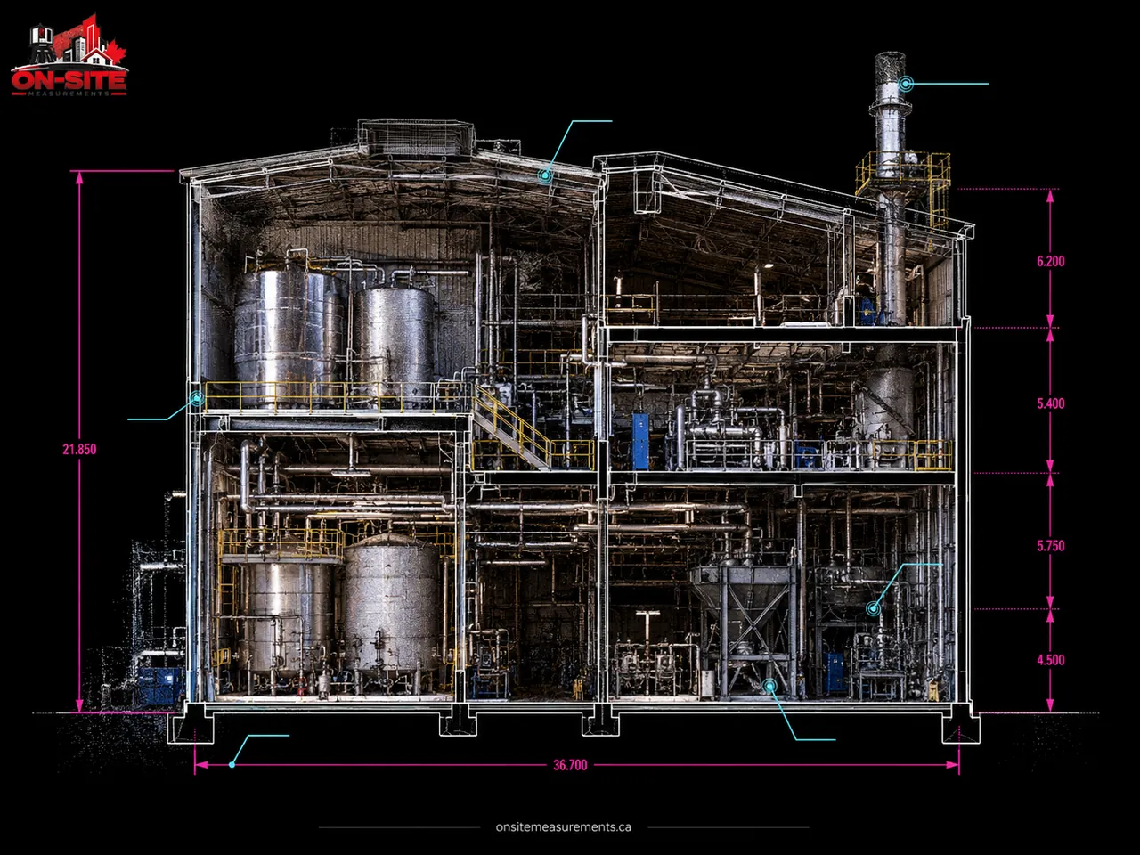
A scanned cross-section exposes existing tanks, piping, and structure for accurate retrofit and MEP coordination.
Why Calgary Industrial Facilities Use Scan-to-BIM
Industrial facilities present a specific documentation challenge. The volume of visible MEP systems, structural steel, equipment connections, and process piping is high, and the spatial relationships between these elements matter directly to retrofit and coordination work. A drawing that approximates the position of a pipe run or a structural member can introduce coordination errors that become expensive to resolve during construction.
Laser scanning captures the actual position of every visible element at the time of capture. A Revit model built from that scan data reflects reality rather than an approximation.
Common Scan-to-BIM applications on Calgary industrial projects include:
Retrofit and process upgrade planning. When an existing facility is being modified to accommodate new equipment, process changes, or expanded capacity, the design team needs an accurate model of what is already there. Scan-to-BIM provides that model so new equipment and connections can be coordinated against existing conditions before anything is fabricated or installed.
MEP and piping coordination. Mechanical, electrical, and piping systems in Calgary industrial facilities are often dense and modified over time. A BIM model of existing MEP allows the project team to coordinate new routing against what exists without relying on field verification for every connection point.
Structural documentation for expansion or modification. When an existing structural system needs to be assessed or extended, a model of the existing structure gives the engineering team a reliable base to work from.
Facility record documentation. Industrial facilities that lack a current BIM record can use Scan-to-BIM to create a baseline model for facility management, operations planning, and future capital projects.
What the Workflow Looks Like
Scan planning and coordination. Before mobilization, the project team confirms the areas to be scanned, any restricted zones (hot work areas, active process areas, confined spaces), and safety protocols for the site. On active industrial sites in Calgary, safety requirements and site entry protocols are confirmed before the crew mobilizes.
Field scanning. The scanner captures the facility from multiple positions. On industrial sites, this includes structural framing, visible MEP, equipment, piping, platforms, and access structures within the agreed scope. Active process areas that cannot be safely accessed are flagged and noted in the scan documentation.
Registration. All scan positions are registered into a single point cloud. On large industrial sites with complex geometry, registration is carried out carefully and reviewed before the cloud is used for modeling.
BIM modeling. The Revit model is built by a technician from the registered point cloud. Elements are modeled to the agreed Level of Development for each discipline. Industrial projects typically require LOD 300 for structural and LOD 350 for MEP and piping where coordination is the primary deliverable.
Model delivery. The completed Revit model and the registered point cloud are delivered together. The cloud is the reference source if the team needs to verify any modeled element or measure against conditions not included in the primary modeling scope.
Levels of Development on Calgary Industrial Projects
Industrial projects often require a higher level of MEP and piping detail than typical commercial renovation work. LOD selection depends on how the model will be used.
LOD 300. Geometry, location, and orientation confirmed from scan data. Appropriate for structural documentation, facility planning, and renovation design where exact connection details are not required.
LOD 350. Adds interface and connection detail. Required for MEP and piping coordination where the routing of new services relative to existing elements needs to be confirmed. Used on retrofit and process upgrade projects where clash coordination is the primary output.
LOD and discipline scope are agreed before modeling begins. Industrial projects with complex systems may require a phased approach where priority areas are modeled first.
Scope and Limitations
Scan-to-BIM captures and models visible elements. Conditions inside insulated pipe, behind cladding or lagging, within enclosed ductwork, or below grade are out of scope. On industrial sites where insulation or cladding obscures system dimensions, the model reflects the outer envelope of the insulated element rather than the pipe or duct inside.
Active process areas that cannot be safely accessed during the field engagement will not be captured. Areas inaccessible at the time of scanning should be confirmed with the project team before mobilization so the scan plan can account for them.
The Scan-to-BIM model is an existing-condition documentation deliverable. It is not an engineering deliverable, safety assessment, or structural analysis. Engineering review of the existing facility remains the responsibility of the project's engineering team.
What to Prepare Before Requesting a Quote
- Site address and facility type
- Areas to be scanned and modeled (building zones, floors, process areas)
- Discipline scope: structural, MEP, piping, or combination
- Required LOD per discipline
- Any restricted areas, active process zones, or confined spaces
- Site safety requirements and entry protocols
- Existing drawings or as-built records, if available
- Required deliverable format: RVT, IFC, or both
- Project schedule and required delivery date
Send project details to mike@onsitemeasurements.ca and we will respond within 24 hours with a scope and price.
Related Services and Resources
- Scan-to-BIM Services, full service description and LOD guide
- 3D Laser Scanning Services, the field capture workflow that feeds BIM production
- Scan-to-BIM in Calgary, local service context for Calgary projects
- Industrial & Manufacturing Industry Page, how BIM documentation supports industrial facility teams
Frequently Asked Questions
Can scanning happen on an active industrial site in Calgary?
Yes, with coordination. Scanning is non-contact and does not require process shutdowns. The field crew works around active operations in areas where safe access is available. Restricted zones, hot work permits, safety inductions, and PPE requirements are confirmed with the site safety lead before mobilization.
What happens if part of the facility is inaccessible during scanning?
Areas not accessible during the field engagement are not captured and are not included in the model. If access becomes available later, a follow-up scan can be arranged to capture those areas separately. Coverage gaps are confirmed with the project team before the crew demobilizes.
Can the model be used for a structural engineering assessment?
The Scan-to-BIM model reflects visible existing conditions. It is an existing-condition documentation deliverable, not a structural engineering deliverable. Structural engineering assessment, load calculations, and connection review remain the responsibility of the project's structural engineer.
What file formats are delivered?
Revit model in RVT format is the standard deliverable. IFC is available if your project requires an open BIM format. The registered point cloud is delivered as E57 and RCP alongside the model. Additional formats can be confirmed at the time of quoting.
Does the scope include above-grade structures and mezzanines?
Yes, if they are included in the agreed scan scope. Mezzanines, elevated platforms, pipe racks, and above-grade structural elements can be captured and modeled when included in scope. Access requirements for elevated areas should be confirmed before mobilization.
Related Pages
The service and city pages behind this project.